|
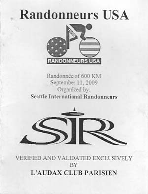
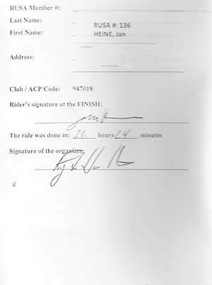
Ride Report Ride: Washington State Challenge 2: Seattle International Randonneurs Fall 2009 Mountain 600 km brevet Distance: 602 km (376 miles) Date: September 11-13, 2009 Time completed: 26:24 hours Rider: Jan Heine Bicycle: Alex Singer Randonneur (Grand Bois Cyprès 700C x 30 mm tires), with SON20R generator hub and LED headlight. Route: Enumclaw-Paradise (Mt. Rainier)-Windy Ridge (Mt. St. Helens)-White Pass-Chinook Pass-Cayuse Pass-White River(Mt. Rainier)-Enumclaw Click here for an official route sheet. (If link does not work, try this one.) |
|
Challenge No. 2 Seattle International Randonneurs Mountain 600 km Brevet By Jan Heine At 2 a.m. on Saturday, I stop my bike just before reaching Ricksecker Point on the long climb to Paradise. Across the valley is the huge cone of Mount Rainier, illuminated faintly by the half-moon. A thousand feet below me, the newborn Nisqually River rushes down its gravelly bed, its waters finally free of the glacier that spawned it. The river makes the only sound that resonates this warm night. A shooting star vanishes behind the ridge on the other side of the valley. I have not seen a car in an hour. I begin to enjoy this ride. "This ride" is the Seattle International Randonneurs "Mountain 600 km" brevet. It goes around Mount Rainier in a large figure-8 loop, with four major climbs to Paradise on Mount Rainier, to Windy Ridge on Mount St. Helens, then cross the Cascade Range via White Pass, before returning over Chinook Pass. Much of the ride is on backroads, often far away from the next human habitation. Earlier, I had seen Mount Rainier's snow-capped cone glow in the evening light as I rode with my friend Ryan Hamilton from Seattle to the start in Enumclaw. As organizers of the ride, we wanted to support the ride without using cars, so Ryan rode a more direct route across the Cascades to the "overnight" control, while I was going to ride the route itself to ensure all roads were open. |
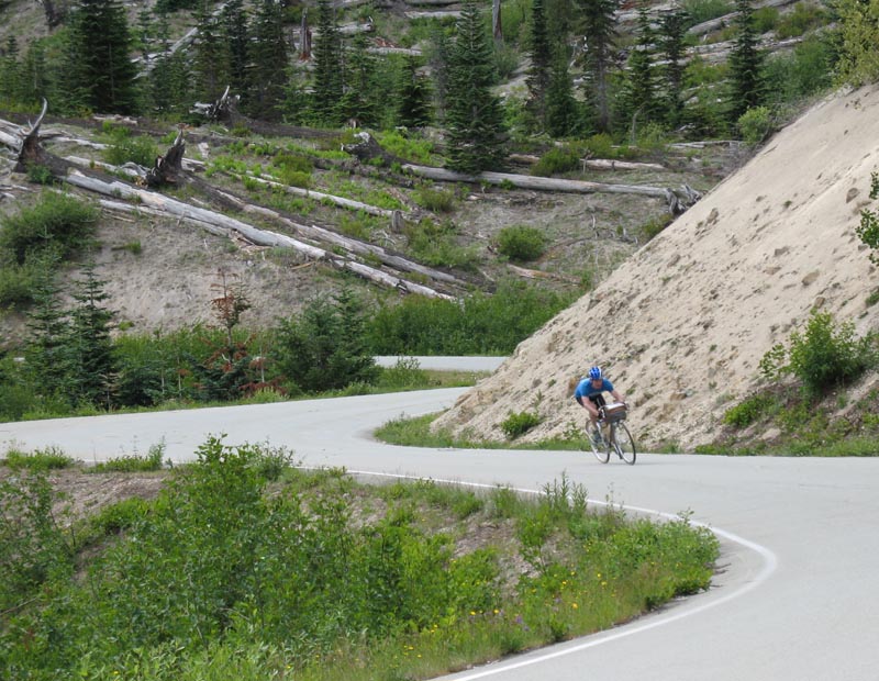
Click on image for large-resolution version. There are no photos from this ride... Here Jan descends from Windy Ridge on a pre-ride in 2008.
|
It was dark when the brevet started at 9 p.m. We rode on familiar roads along the foothills of Mount Rainier. I teamed up with Kole Kantner, an amazing rider who seems to spend every waking hour on a bike. He already had ridden the pre-ride a week earlier, and now was pushing the pace again. I let him go ahead just before the first climb, knowing I would not be able to keep up. As I saw Kole's red taillight vanish in the distance, I wondered whether he would be able to keep up his ferocious pace. My goal is to finish the ride in less than 28 hours, to complete the Cyclos Montagnards Washington State Challenge No. 2. The first climb of a long ride often is challenging for me, as my body has not yet got into the rhythm of climbing for hours without interruption. Often, a brief stop helps me regain my focus, which is why I stopped in the middle of the climb at Ricksecker Point. As I get going again, I realize that my stop has worked. Climbing mountain passes always seems easier at night than during daytime, and I soon reach Paradise, at 1650 m (5400 feet) the highest point of the ride. The control here is at the Visitor Center. Of course, the Visitor Center is closed in the middle of the night, so the control is "informational." Usually, this means that riders answer a question like "How many recycling cans are in front of the building," but to make everybody's life easier, I am placing stickers that riders can peel off and stick on their brevet cards as proof that they have been here. Kole is still here, and so is Steve Frey, who passed me when I pulled off the course at a campground to get water. I give them their stickers, and they take off down the hill. With the stickers in place, I point my bike down the hill. Remembering the road from Ramrod (Ride Around Mount Rainier in One Day) and other rides helps here, as does my IQ Cyo LED headlight that provides ample illumination. I soon pass Steve, and then see Kole on the road below, one hairpin turn ahead of me. As the road straightens out, I get in the aero tuck, and catch him just before Box Canyon. Looking back, we get another glimpse of Mount Rainier in the moonlight. Then I roll ahead on the downhill. We may meet up again down the road, but with so many climbs and descents, I find it easiest to ride at my own pace. A quick stop in Packwood at a 24-hour gas station provides water and supplies for the long leg to Mount St. Helens and back. The gas station attendant has seen randonneurs before, so he isn't the least bit surprised when riders pull in at 3 a.m. Rolling along the valley provides some nice rest, both mentally and physically, after Mount Rainier's demanding topography. Much of the course follows the old road, which has a nice rhythm as it winds its way along the valley sides, safely out of the way of all but the largest floods. |
The brevet's evening start worked well for most riders. It enabled them to complete much of the climbing before the lunchtime heat. |
At 5:30 a.m., I cross the Cowlitz River at in Randle. The bridge here is not simply a conveyance across a river, but also a portal to another world. From here, I will ride more than 50 kilometers on small mountain roads, simple ribbons of asphalt with no lane markings, until I reach Windy Ridge. I won't see another house, and only a handful of cars, until I emerge from this mountainous world in five hours' time. My favorite roads always make me go faster, and I accelerate as I ride through the forest. I stash my extra food and a water bottle inside the guardrail of a bridge, hidden from view. There is no need to carry an extra 4 kg (9 lbs.) up the 1500 m (5000 feet) to Windy Ridge and back. I will retrieve them when I return. The unmarked turnoff to Forest Road 26 indicates that the climbing starts in earnest. Almost imperceptibly, twilight has arrived, and I can make out the road beyond the beam of my headlight. As I climb, I notice the bright yellow dawn behind the ridges to the east. Then I get another view of Mount Rainier, this time from the southwest, its dome glinting majestically in the morning light. The road is steep here, and when I rode this climb in June during our original Cyclos Montagnards Challenge, I was suffering. Now I am in better shape, and have found a good rhythm. The bike and I work in perfect harmony at a pace that seems sustainable indefinitely. I love this narrow road, which now turns into a long downhill. A few gravel patches require my full attention, but even with comparatively narrow 32 mm tires, the bike flies over them just fine. Then more climbing follows. My light has become superfluous, so I turn it off. I reach Norway Pass, but the climbing isn't over yet. On the rollers that follow, I try to carry as much momentum as I can into each uphill by using the aero tuck to full advantage on the short, but steep downhills. However, a section of 18% slope zaps my momentum, and I struggle. I decide to stop, use the bathroom, and then walk the 20 meters (60 feet) to the top. Walking relaxes my legs, whereas pushing up this incline might have hurt my knees. I am now in the blast zone from the 1980 eruption of Mount St. Helens now. Almost 30 years after the cataclysm, the landscape still is littered with fallen trees. Shrubs cover the landscape today, and ash has washed over the road in places. During the downhills, I approach corners with care, lest I hit a patch of ash with dire consequences. I enjoy the crisp morning air, and almost unexpectedly reach the top, descend to the main road, where volunteer John Pearch has spent the night. He already is up, and has prepared pancakes! Having a friend in this forbidding landscape is touching. I check in with him, then continue to Windy Ridge. |
|
The truncated flanks of Mount St. Helens are covered with a dusting of new snow. The forbidding crater looms ahead, getting bigger with each ridge I cross. I recall hiking into the crater with a geology field trip 17 years ago, when this landscape was even more barren and new. I reach Windy Ridge and affix my stickers to a sign, then turn around. The week before, Kole and Vincent Muoneke had difficulty staying upright in the rainstorm as Windy Ridge lived up to its name. Not so this balmy morning. The air is so clear that I can see Mount Hood in Oregon to the south. Straight ahead and due east is Mount Adams, backlit by the morning sun. Then I turn a corner and there is my old friend, Mount Rainier, again. Looking back, I see the crater of Mount St. Helens. This may be the first time I have seen four volcanoes from the same spot on the ground. The descent is an almost continuous sequence of curves (see photo on right at beginning of article). My well-worn tires grip the pavement as I lean the bike harder with each turn, building speed on the short straights in the aero tuck. Then I meet Kole heading the other way. I calculate that he is about 45 minutes behind. The fatigue of the previous weekend may be beginning to show. All too soon, I reach John's camp, eat a few pancakes, then head on as Steve arrives on his way out. As I climb toward Bear Meadow past the dead trunks of huge trees, killed by the blast but still standing, I drink the last from my bottle and eat the last bite of energy bar. My estimate for the supplies need for the climbing to Windy Ridge was about right. Another exhilarating descent follows. I take it easy on two tricky hairpins, then roll onto the bridge where I have stashed my food and drink. I find my bottles of liquid meal replacement and my spare water bottle, but where is my clear plastic bag with my energy bars? The bag isn't far, shredded by sharp beaks. And the bars are gone, without a trace. Not even a wrapper is left. How could I forget the attraction of colorful wrappers to birds, especially near campgrounds, where birds know that the colorful wrappers contain food? There is no use crying over spilled energy bars, so I head on toward Packwood. Riding along the Cowlitz River, the road surface of Cline Road feels rougher than usual today. I wish for tires wider than my 32 mm. The canopies of the trees touch above the road, providing a nice pattern of light and shadow on the road. A few short climbs make me stretch my legs, before a sharp descent spits me into the bucolic farmland of the Cowlitz River valley. Like a great symphony, a good ride has a nice rhythm, and I appreciate the less demanding interludes between the mountain "stages." |
|
In Packwood, I stop at the same gas station where I had been 8 hours earlier. I find some Powerbars that replace the bars lost to the birds. At the edge of town, the climb toward White Pass begins. After a few gentle rollers, it soon increases in steepness. Traffic is light, but the sun is at the highest point along its orb across the sky. I break up the relentless grade by stopping a few scenic turnoff to look at a waterfalls on the other side of the forested valley. As I continue, my feet begin to hurt from the heat. When I see a puddle of muddy water by the roadside, left from the previous week's tempest, I stop to bathe my feet and shoes, and the pain disappears. The climb to White Pass is 32 km long. It helps to know that the gradient eases after the first third. In the heat, I am not out to set any records half-way through the ride, too far into the ride to feel the excitement of the early miles, and too early to speed up for the finale. The descent to the "overnight" control at Rimrock Lake is spoiled slightly by a headwind, but a descent is a descent, and I reach "Snug Harbor" in good spirits. Ryan has ridden his bike here during the night to staff the control. He is asleep as I arrive, but the soup on the stove is warm, providing a welcome break from packaged energy foods. We have a brief "brevet organizers' meeting." I eat a second bowl of soup, then head out after 20 minutes off the bike. Traffic is heavy in the early afternoon, but the shoulder is clean and smooth. I see the water rushing out of the dam below, then descend into the valley of the Tieton River. The landscape east of the Cascades feels so different from the mountains where we usually ride. Trees are sparse on the hillsides, then vanish entirely as I move eastward. Basalt columns line the road, narrowing the valley and forming rapids in the river. It's a favorite spot for rafting, and I envy their spot on the cool river during this hot afternoon. We wave at each other, and I realize that I cannot complain. The headwind has turned into a ¾ tailwind as I head northeast. I buy another soft drink to cope with the heat, then continue. As the valley narrows even more, I see an ominous sign: "Road Works Ahead. 30 minute delay." Soon I see a long line of cars and trucks. As I roll to the front, I see every vehicle that has passed me in the hour or so since I left the control. A lone flagger at the front is sweating in the heat. He explains: "Rockfall. It'll be open soon. But I'll let the cars through first, so they don't have to pass you again. That will take a while." Since the road does not have a shoulder, I prefer not to ride in front of a mile-long queue of impatient cars. I feel deflated. For more than 18 hours, I have pedaled hard, limited my stops to the bare minimum, only to be thwarted here by a few truck-sized boulders that crashed onto the road. Resigned to fate, I lay down my bike on the gravel and climb down to the river. I step into the cool waters, immerse my legs, and enjoy the gentle massage of the fast-flowing water. After a few minutes, the water gets too cold, and I climb back up to the road. The next ten minutes seem like an eternity. Then a pilot truck appears, with a line of cars coming toward us. Soon, I will be on the road again! Not so quick: An eternity passes before each direction's two mile-long queues of cars has passed. Finally, I start pedaling again, 37 minutes after I stopped. Soon I come upon the slide. Large loaders are still at work clearing the other lane of boulders. |
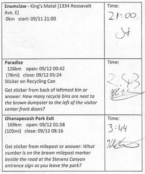
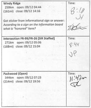
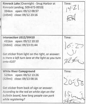
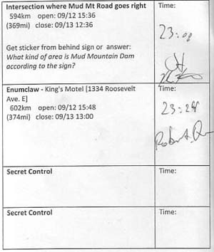
Who signed the card? As the brevet organizer, Jan left small stickers at "informational" controls. The other riders each picked up a sticker and attached it to their control card. The presence of the stickers (countersigned by another rider, Kole Kantner, before the start to make sure they were not placed in advance) proved that Jan had been at each control, and completed the entire course. Kole signed Jan's card at the finish, confirming that all stickers had been in place. At other controls and at the finish, the card was signed by SIR members, gas station attendants and others. |
The turnoff to Highway 410 marks the beginning of the climb to Chinook Pass. For 75 km (47 miles), the road will only climb, gently first and then steeper. It is the grand finale of this ride. The last time I climbed this road was in the middle of the night during a weekday, and I enjoyed having the road to myself, seeing only four or five cars during the entire climb. How I wish for such solitude now! It feels like a great exodus is happening in Yakima, with half the population driving their trucks up the pass. Where are they going? Enumclaw isn't a popular destination. Tacoma perhaps? At least the drivers are friendly, giving me plenty of room as they pass. I remember that during my last ride, I was battling howling headwinds in the narrow valley. This afternoon, the gods are on my side, and a strong easterly wind blows up the valley. The miles pass with little effort as I gain elevation. I stop at Cliffdell, my last supply opportunity before the night and the mountains. I linger a little longer here, knowing that I won't get off my bike again until the finish in six hours. Halfway up the pass, it still is warm, and I suddenly realize that my two water bottles might not be enough to get me over the pass. I have passed the last campground with water. When I see two hikers get into their car, I ask them for water, and they have some to spare. I continue my ascent. Until now, I have climbed smoothly in my "big" chainring (48 teeth), making very good time. But I know the last few miles of the pass are unrelenting in their steepness. The top comes into view, but I know that the hard work is only beginning. The trees at the pass look small, but they are giant, and I can barely discern a car on the road ahead. I do not have a computer on my bike, but the mile markers indicate that 5 miles (8 km) remain to be climbed. Having seen Mount Rainier from three sides during this ride, I really want to see my favorite peak from the east when I crest the top. The light is fading already, so I have to hurry to make this appointment. I work hard to pedal smoothly in my 32-21, the biggest gear I ever have used on this climb. My bike becomes an extension of my body, and still pushed by the gentle tailwind, we soar up the road, which climbs high above the valley, surrounded by talus slopes. I envision myself as an eagle gliding on the thermal updrafts, as darkness descends around me. I give it everything I have, knowing that the last 100 km of this ride are almost all downhill. Tonight, Chinook Pass is the end of the ride, and I ride accordingly. It is 7:55 when I pull off at the parking lot just below Chinook Pass. I am panting as I pull on my arm and leg warmers, turn on my light, then climb the remaining hundred meters to the pass to warm up again before starting the descent. As I crest, I see the majestic black dome of Mount Rainier outlined against the blue evening sky. I made it! In the darkness, I descend with caution. The bike wants to roll, and I rein it in by braking hard from time to time, allowing the rims to cool in between. It is pitch dark when I reach Cayuse Pass and return to more familiar roads. The bike flies now, I am going at least 45 mph. The speed limit is 35, yet several cars insist on passing me. It doesn't take long to reach the turnoff to Sunrise. I enter the park again and begin the climb toward the White River Campground. With my energy spent, it seems like a relentless uphill, even though we aren't doing the "real" climb to Sunrise. Looking up through the tall trees, I see the stars in amazing clarity. The Milky Way stretches above, and a bright shooting star vanishes behind Mount Rainier. I can make out the mountain only because it blocks the stars, leaving a black triangle in the sky. The moon won't rise for another few hours. Finally, I reach the campground, attach my stickers to the sign-in board, and turn around. It takes only a few minutes to reach the park entrance, where I fill up my water bottles one last time. Even though I have been on the road for 24 hours, I do not feel sleepy. The climb to the main road tests my weary legs, then I tuck as the bike races downvalley again. The wind rushing by my ears drowns the noise of the tires on the road and the clicking of the freewheel. When the road flattens out, I look at my watch. It should be possible to do better than 27 hours. The final miles could be a long slog. Instead, they turn into a challenge. I spin my gears as fast as I can, use the aero tuck on the steeper sections, and work smoothly on the straight parts. Traffic has died down, and the road has few features. Riding along at full effort is meditative, and the time passes quickly. I recognize landmarks, zoom through Greenwater, and soon reach the turnoff to Mud Mountain Dam. As I stop at the last informational control, I am out of breath and have a hard time finding a good spot for my stickers. The descent of Mud Mountain Dam always is exciting, even more so in the dark. Again, I take it easy, and accelerate only as I reach the valley. With the adrenaline from knowing the finish near, bike and rider surge ahead. A car slowly approaches from behind, but does not pass. They may wonder why I am riding on this farm road like a man possessed in the middle of the night. The last two miles always are longer than I remember, and I am glad to see Kings Motel appear on my right. I pull up at the night window, and the surprised clerk signs my card and hands me a key to our room. I check my card: I arrived at 11:24 p.m., 26:24 hours after I started. I made my goal. Now it's time to get some sleep. |
26:24 hours! Success in the Cyclos Montagnards Challenge. |
|
|
|
|
|
|
|
|
|
|
|
|
|
|
|
|